|
Describes the ground water conditions and water level trends in the Waterman Wash area. Maps, graphs, chemical analyses. List of previous hydrological investigations.
Resource Identifiers: http://resources.usgin.org/uri_gin/dlio/110
|
|
Describe briefly all the springs visited during the 1960 trip and to compile all known additional discharge data from the springs. Maps, cross section, flow graphs, chemical analyses.
Resource Identifiers: http://resources.usgin.org/uri_gin/dlio/107
|
|
Provide data for analyses of floods. Objectives of flood magnitude, frequency, inundation, duration, channel effects, hydrographs, and rainfall and runoff relationships. Map and tables of gaging...
Resource Identifiers: http://resources.usgin.org/uri_gin/dlio/104
|
|
Investigate the flow characteristics in the channel, and infiltration and recharge to the ground water from increased flow in the channel. Maps, photos. Graphs showing changes in surface waters and...
Resource Identifiers: http://resources.usgin.org/uri_gin/dlio/102
|
|
Shows the changes caused by additional water to the East Verde River. Streamflow graphs. Map. Includes ground seepage, erosion and evapotranspiration considerations.
Resource Identifiers: http://resources.usgin.org/uri_gin/dlio/101
|
|
Summary of the basic hydrologic data for the three Valleys. Maps and graphs of water levels and wells. Well records. Drillers' logs. Chemical analyses.
Resource Identifiers: http://resources.usgin.org/uri_gin/dlio/99
|
|
Reports a more detailed study of hydrologic and geologic data than is feasible in the annual report covering the entire state. Maps and graphs of water levels and changes. Drillers' logs,...
Resource Identifiers: http://resources.usgin.org/uri_gin/dlio/98
|
|
Summary of basic hydrologic data and trends. Illustrations include hydrographs and maps of water levels and changes. Precipitation table. Discussions of the ground-water conditions in selected...
Resource Identifiers: http://resources.usgin.org/uri_gin/dlio/97
|
|
Bibliography of reports from 1891 to 1965. Grouped by report type. Lists of maps.
Resource Identifiers: http://resources.usgin.org/uri_gin/dlio/95
|
|
Summary of basic hydrologic data and trends. Illustrations include hydrographs and maps of water levels and changes. Precipitation table. Discussions of the ground-water conditions in selected...
Resource Identifiers: http://resources.usgin.org/uri_gin/dlio/92
|
|
Purpose is to make available selected well records, drillers' logs, and quality-of-water information. Investigation of the second largest agricultural area in the State consisted of evaluating...
Resource Identifiers: http://resources.usgin.org/uri_gin/dlio/91
|
|
Study to determine the feasibility of making predictions of the future effects of ground-water withdrawal with the data available. Maps.
Resource Identifiers: http://resources.usgin.org/uri_gin/dlio/89
|
|
Supplement for the previous report completed in 1956. Compilation of the records of drilled wells, dug wells, and springs.
Resource Identifiers: http://resources.usgin.org/uri_gin/dlio/85
|
|
Maps showing locations of wells, springs, and stratigraphic sections
Resource Identifiers: http://resources.usgin.org/uri_gin/dlio/84
|
|
Consists of the chemical quality of the ground water in Navajo and Hopi Indian Reservation. Selected lithologic logs, drillers' logs, and stratigraphic sections.
Resource Identifiers: http://resources.usgin.org/uri_gin/dlio/83
|
|
Compilation of selected chemical analyses from the wells and springs that were sampled.
Resource Identifiers: http://resources.usgin.org/uri_gin/dlio/82
|
|
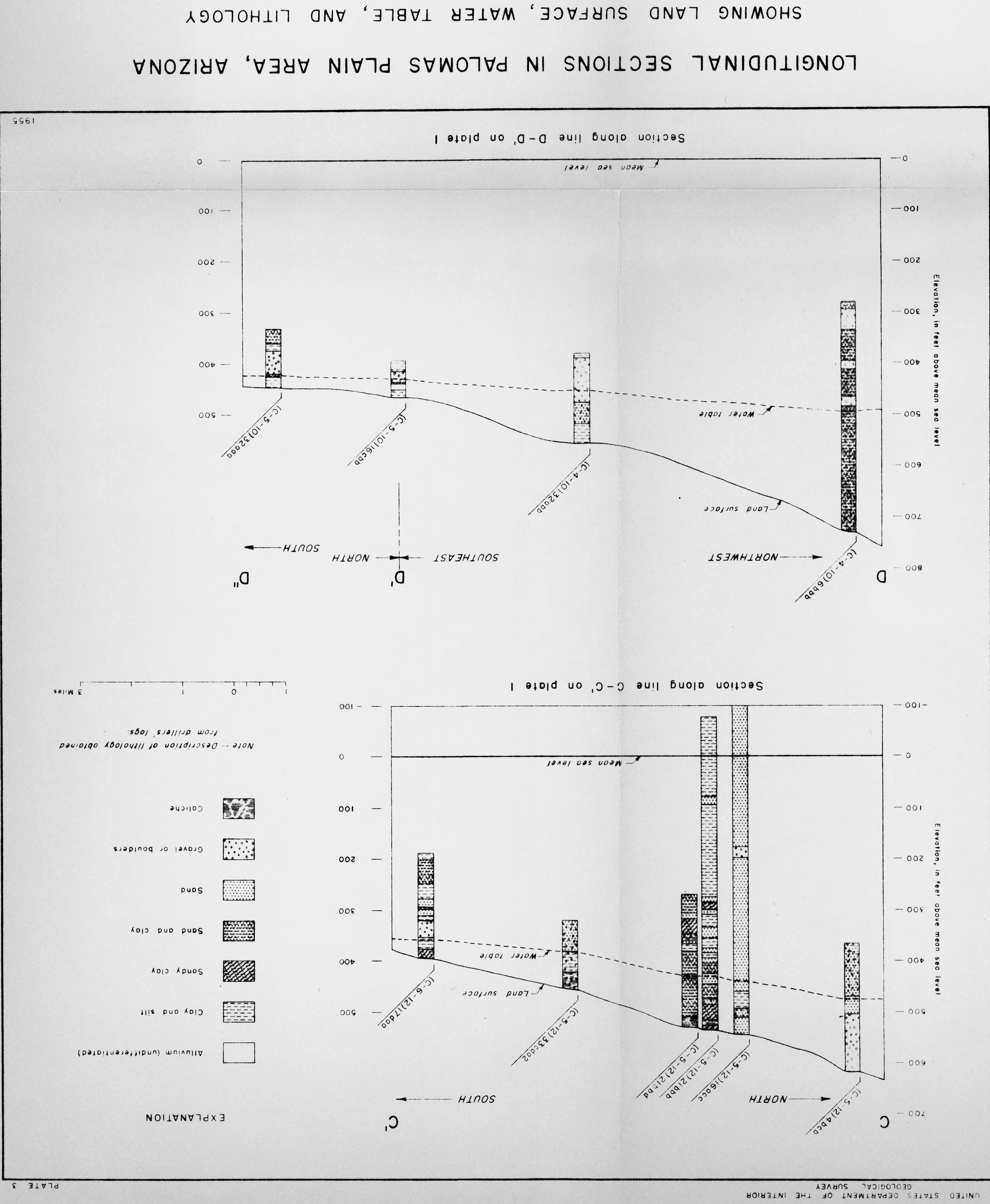
Made to ascertain geologic and hydrologic conditions in the underdeveloped McMullen Valley and to determine the probable effects of ground water use. Data pertaining to lithologic characteristics of...
Resource Identifiers: http://resources.usgin.org/uri_gin/dlio/77
|
|
Determine the geologic and hydrologic characteristics of the area before the development of ground water reached an advanced stage. Hydrologic, geologic and geographic description of area. Maps,...
Resource Identifiers: http://resources.usgin.org/uri_gin/dlio/73
|
|
Field inventory consists of compilation of the records of drilled wells, dug wells, and springs which were inventoried before 1957. Report summarizes the results of bailing and pumping tests of the...
Resource Identifiers: http://resources.usgin.org/uri_gin/dlio/81
|
|
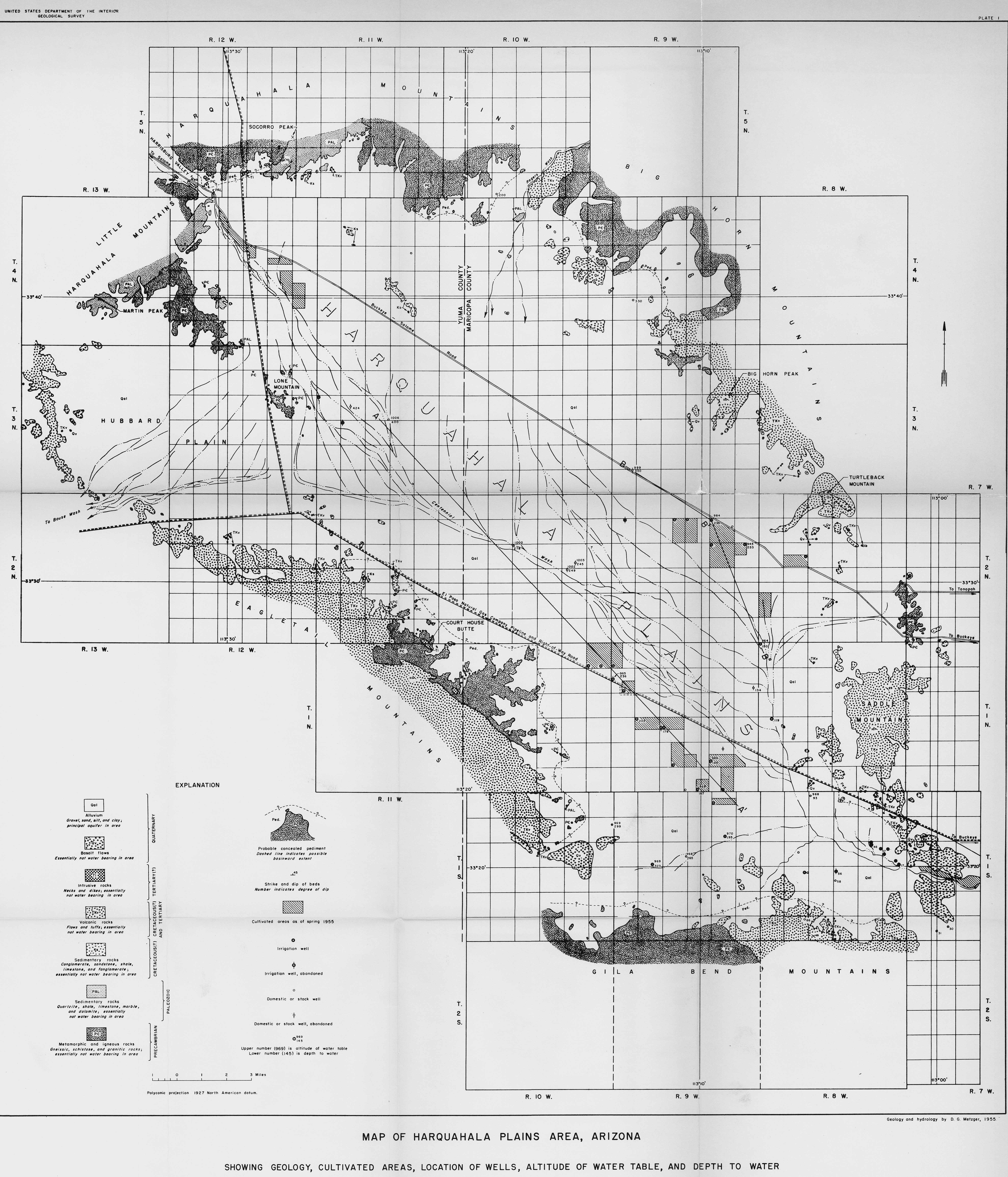
Study of ground water resources of the Harquahala Plains. Hydrologic, geographic and geologic summary. Qualitative report of general relationships and relative magnitudes between hydrologic...
Resource Identifiers: http://resources.usgin.org/uri_gin/dlio/72
|
Collection of documents related to Arizona geothermal resources and data
![]() 2 members
2 members