Maricopa County

Geohydrology of the Dateland-Hyder Area, Maricopa and Yuma Counties, Arizona

Basic Information
Author: 
Weist Jr., W.G.
Description: 
Determine the location of large supplies of ground water, how much is being used, and the advisability of increasing the development of the ground water reservoir. Maps, hydrographs. Tables of wells, drillers' logs, water levels, chemistry.
Publication Date: 
Monday, November 1, 1965
Resource Language: 
English
Intelectual Originator Contact
Organization Name: 
Arizona State Land Department
Street Address: 
1616 W Adams St.
City: 
Phoenix
State/Province: 
Arizona
Postal Code: 
85007
Country: 
United States
Phone: 
602-542-4631
Resource Information
Resource ID: 
http://resources.usgin.org/uri_gin/dlio/96
Resource Distribution Contact
Organization Name: 
Arizona Geological Survey
Street Address: 
416 W Congress St. Suite 100
City: 
Tucson
State/Province: 
Arizona
Postal Code: 
85701
Country: 
United States
Phone: 
5207703500
Fax: 
5207703505
Geographic Extent
North bounding latitude: 
33.1425
South bounding latitude: 
32.6606
West bounding longitude: 
-113.708
East bounding longitude: 
-113.07
Previous Citation
Bibliographic Citation: 
Weist Jr., W.G. 1965. Geohydrology of the Dateland-Hyder Area, Maricopa and Yuma Counties, Arizona: Arizona State Land Department, Phoenix, Water Resource Report 23, 46 pp.

Effects of Ground Water Withdrawal, 1954-63, in Lower Harquahala Plains, Maricopa County, Arizona

Basic Information
Author: 
Stulik, R.S.
Description: 
Utilization of ground-water resources for irrigation and accompanying effects on the ground-water reservoir. Maps.
Publication Date: 
Tuesday, September 1, 1964
Resource Language: 
English
Intelectual Originator Contact
Organization Name: 
Arizona State Land Department
Street Address: 
1616 W Adams Street
City: 
Phoenix
State/Province: 
Arizona
Postal Code: 
85007
Country: 
United States
Phone: 
602-542-4631
Resource Information
Resource ID: 
http://resources.usgin.org/uri_gin/dlio/90
Quality Statement: 
Blank pages intentionally removed (place holders for reproduction)
Resource Distribution Contact
Organization Name: 
Arizona Geological Survey
Street Address: 
416 W Congress St. Suite 100
City: 
Tucson
State/Province: 
Arizona
Postal Code: 
85701
Country: 
United States
Phone: 
520-770-3500
Fax: 
520-770-3505
Geographic Extent
North bounding latitude: 
33.4891
South bounding latitude: 
33.085
West bounding longitude: 
-112.95
East bounding longitude: 
-112.335
Temporal Extent
Temporal Extent: 
1954-01-01 - 1963-12-31
Previous Citation
Bibliographic Citation: 
Stulik, R.S. 1964. Effects of Ground Water Withdrawal, 1954-63, in Lower Harquahala Plains, Maricopa County, Arizona: Arizona State Land Department, Phoenix, Water Resource Report 17, 8 pp.

Effects of Ground Water Withdrawal in Part of Central Arizona Projected to 1969

Basic Information
Author: 
White, N.D.
Author: 
Stulik, R.S.
Author: 
Rauh, Clara L.
Description: 
Study to determine the feasibility of making predictions of the future effects of ground-water withdrawal with the data available. Maps.
Publication Date: 
Wednesday, July 1, 1964
Resource Language: 
English
Intelectual Originator Contact
Organization Name: 
Arizona State Land Department
Street Address: 
1616 W Adams Street
City: 
Phoenix
State/Province: 
Arizona
Postal Code: 
85007
Country: 
United States
Phone: 
602-542-4631
Resource Information
Resource ID: 
http://resources.usgin.org/uri_gin/dlio/89
Resource Distribution Contact
Organization Name: 
Arizona Geological Survey
Street Address: 
416 W Congress St. Suite 100
City: 
Tucson
State/Province: 
Arizona
Postal Code: 
85701
Country: 
United States
Phone: 
5207703500
Fax: 
5207703505
Geographic Extent
North bounding latitude: 
33.864
South bounding latitude: 
32.4105
West bounding longitude: 
-112.533
East bounding longitude: 
-110.803
Previous Citation
Bibliographic Citation: 
White, N.D., Stulik, R.S. and Rauh, C.L. 1964. Effects of Ground-Water withdrawal in Part of Central Arizona Projected to 1969: Arizona State Land Department, Phoenix, Water Resource Report 16, 25 pp.

Desert Floods - A Report on Southern Arizona Floods of September, 1962

Basic Information
Author: 
Lewis, Douglas D.
Description: 
Report of Arizona floods in September, 1962. Descriptions of storm, flood and flood damage. Illustrations include maps, photos, charts.
Publication Date: 
Tuesday, January 1, 1963
Resource Language: 
English
Intelectual Originator Contact
Organization Name: 
Arizona State Land Department
Street Address: 
1616 W Adams St
City: 
Phoenix
State/Province: 
Arizona
Postal Code: 
85007
Country: 
United States
Phone: 
602-542-4631
Resource Information
Resource ID: 
http://resources.usgin.org/uri_gin/dlio/86
Resource Distribution Contact
Organization Name: 
Arizona Geological Survey
Street Address: 
416 W. Congress St. Suite 100
City: 
Tucson
State/Province: 
Arizona
Postal Code: 
85701
Country: 
United States
Phone: 
520-770-3500
Fax: 
520-770-3505
Geographic Extent
North bounding latitude: 
33.3011
South bounding latitude: 
31.871
West bounding longitude: 
-112.115
East bounding longitude: 
-110.753
Temporal Extent
Temporal Extent: 
1962-09-01 - 1962-09-30
Previous Citation
Bibliographic Citation: 
Lewis, Douglas D. 1963. Desert Floods - A Report on Southern Arizona Floods of September, 1962: Arizona State Land Department, Phoenix, Water Resource Report 13, 30 pp.

Hydrologic Data and Drillers Logs, Papago Indian Reservation, Arizona

Basic Information
Author: 
Heindle, L.A.
Author: 
Cosner, O.J.
Description: 
Tables of basic well data, drillers logs, and chemical analyses of well water collected by the U.S. Geological Survey on Papago Reservation
Publication Date: 
Saturday, July 1, 1961
Resource Language: 
English
Intelectual Originator Contact
Organization Name: 
Arizona State Land Department
Street Address: 
1616 W Adams St
City: 
Phoenix
State/Province: 
Arizona
Postal Code: 
85007
Country: 
United States
Phone: 
602-542-4631
Resource Information
Resource ID: 
http://resources.usgin.org/uri_gin/dlio/78
Resource Distribution Contact
Organization Name: 
Arizona Geological Survey
Street Address: 
416 W Congress St. Suite 100
City: 
Tucson
State/Province: 
Arizona
Postal Code: 
85701
Country: 
United States
Phone: 
520-770-3500
Fax: 
520-770-3505
Geographic Extent
North bounding latitude: 
32.8869
South bounding latitude: 
31.3
West bounding longitude: 
-112.922
East bounding longitude: 
-110.797
Previous Citation
Bibliographic Citation: 
Heindle, L.A. and Cosner, O.J. 1961. Hydrologic Data and Drillers' Logs, Papago Indian Reservation, Arizona: Arizona State Land Department, Tucson, Water Resource Report 9, 116 pp.

Geology and Ground Water Resources of the McMullen Valley, Maricopa, Yavapai, and Yuma Counties, Arizona

Basic Information
Author: 
Kam, William
Description: 
Made to ascertain geologic and hydrologic conditions in the underdeveloped McMullen Valley and to determine the probable effects of ground water use. Data pertaining to lithologic characteristics of the waterbearing materials and origin, movement, quantity, availability, and quality of the ground water. Maps, graphs, photos.
Publication Date: 
Wednesday, March 1, 1961
Resource Language: 
English
Intelectual Originator Contact
Organization Name: 
Arizona State Land Department
Street Address: 
1616 W Adams St
City: 
Phoenix
State/Province: 
Arizona
Postal Code: 
85007
Country: 
United States
Phone: 
602-542-4631
Resource Information
Resource ID: 
http://resources.usgin.org/uri_gin/dlio/77
Resource Distribution Contact
Organization Name: 
Arizona Geological Survey
Street Address: 
416 W. Congress St. Suite 100
City: 
Tucson
State/Province: 
Arizona
Postal Code: 
85701
Country: 
United States
Phone: 
520-770-3500
Fax: 
520-770-3505
Geographic Extent
North bounding latitude: 
34.4911
South bounding latitude: 
33.7556
West bounding longitude: 
-113.991
East bounding longitude: 
-112.921
Previous Citation
Bibliographic Citation: 
Kam, William. 1961. Geology and Ground Water Resources of the McMullen Valley, Maricopa, Yavapai, and Yuma Counties, Arizona: Arizona State Land Department, Phoenix, Water Resource Report 8, 72 pp.

Geology and Ground-Water Resources of the Palomas Plain - Dendora Valley Area, Maricopa and Yuma Counties, Arizona

Basic Information
Author: 
Armstrong, C.A.
Author: 
Yost Jr., C.B.
Description: 
Determine the geologic and hydrologic characteristics of the area before the development of ground water reached an advanced stage. Hydrologic, geologic and geographic description of area. Maps, cross sections and tables.
Publication Date: 
Wednesday, January 1, 1958
Resource Language: 
English
Intelectual Originator Contact
Organization Name: 
Arizona State Land Department
Street Address: 
1616 W Adams St
City: 
Phoenix
State/Province: 
Arizona
Postal Code: 
85007
Country: 
United States
Phone: 
602-542-4631
Resource Information
Resource ID: 
http://resources.usgin.org/uri_gin/dlio/73
Resource Distribution Contact
Organization Name: 
Arizona Geological Survey
Street Address: 
416 W Congress St. Suite 100
City: 
Tucson
State/Province: 
Arizona
Postal Code: 
85701
Country: 
United States
Phone: 
520-770-3500
Fax: 
520-770-3505
Geographic Extent
North bounding latitude: 
33.864
South bounding latitude: 
32.5541
West bounding longitude: 
-114.477
East bounding longitude: 
-112.686
Previous Citation
Bibliographic Citation: 
Armstrong, C.A and Yost Jr., C.B. 1958. Geology and Ground Water Resources of the Palomas Plain - Dendora Valley Area, Maricopa and Yuma Counties, Arizona: Arizona State Land Department, Phoenix, Water Resource Report 4, 49 pp.

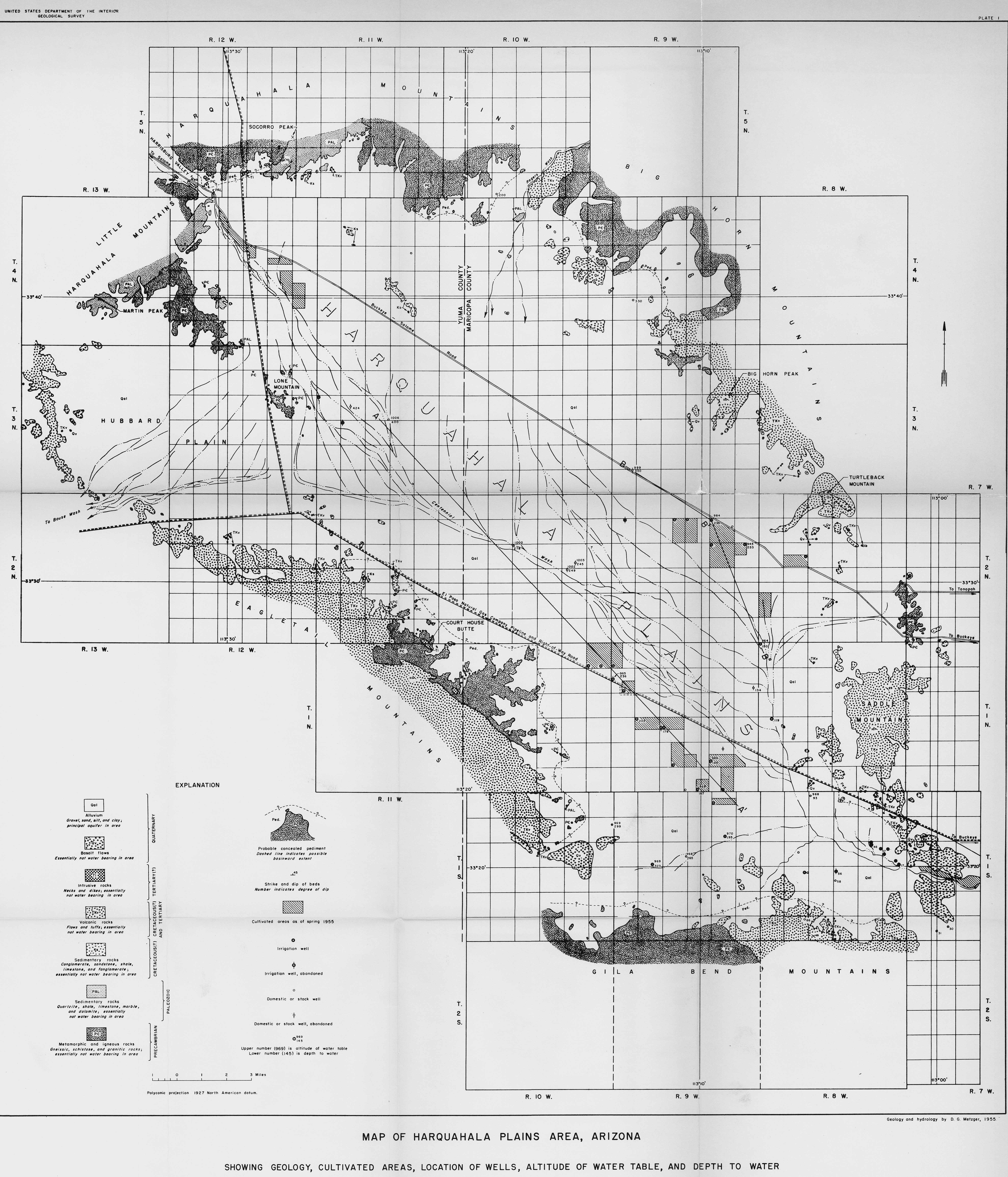
Geology and Ground - Water Resources of the Harquahala Plains Area, Maricopa and Yuma Counties, Arizona

Basic Information
Author: 
Metzger, D.G.
Description: 
Study of ground water resources of the Harquahala Plains. Hydrologic, geographic and geologic summary. Qualitative report of general relationships and relative magnitudes between hydrologic parameters.
Publication Date: 
Sunday, September 1, 1957
Resource Language: 
English
Intelectual Originator Contact
Organization Name: 
Arizona State Land Department
Street Address: 
1616 W Adams St
City: 
Phoenix
State/Province: 
Arizona
Postal Code: 
85007
Country: 
United States
Phone: 
602-542-4631
Resource Information
Resource ID: 
http://resources.usgin.org/uri_gin/dlio/72
Resource Distribution Contact
Organization Name: 
Arizona Geological Survey
Street Address: 
416 W Congress St. Suite 100
City: 
Tucson
State/Province: 
Arizona
Postal Code: 
85701
Country: 
United States
Phone: 
520-770-3500
Fax: 
520-770-3505
Geographic Extent
North bounding latitude: 
33.8457
South bounding latitude: 
33.1035
West bounding longitude: 
-113.774
East bounding longitude: 
-112.791
Previous Citation
Bibliographic Citation: 
Metzger, D.G. 1957. Geology and Ground Water Resources of the Harquahala Plains Area, Maricopa and Yuma Counties, Arizona: Arizona State Land Department, Phoenix, Water Resource Report 3, 39 pp.
Syndicate content