Yuma County

Subsurface Temperature Maps State of Arizona

Basic Information
Author: 
J.N. CONLEY
Author: 
O.A. STACEY
Description: 
This publication presents a tabulation of the temperature and associated data of subsurface rocks and two maps showing the location of wells for which temperature information is available in the files of the Oil and Gas Conservation Commission. Most of this information consists of the bottom hole temperatures measured by geophysical log surveys of wells drilled for oil, natural gas, and helium in the northeastern portion of the Colorado Plateau tectonic province of Arizona. It represents the first phase of a subsurface temperature project designed primarily for the use of earth scientists interested in the geothermal-energy potential of the state. The second phase of the project will present surface water temperature and associated data of numerous wells drilled for irrigation and other purposes located mostly in the Basin and Range tectonic province of Arizona.
Publication Date: 
Wednesday, June 1, 1977
Resource Language: 
English
Intelectual Originator Contact
Organization Name: 
ARIZONA OIL AND GAS CONSERVATION COMMISSION
Person Name: 
J.N. CONLEY | O.A. STACEY
Street Address: 
416 W. Congress At. Suite 100
City: 
Tucson
State/Province: 
Az
Postal Code: 
85701
Country: 
United States
Phone: 
(520) 770-3500
Fax: 
(520) 770-3505
Resource Information
Resource ID: 
http://resources.usgin.org/uri_gin/dlio/155
Access Statement: 
Professional Document and maps
Constraints Statement: 
Public
Quality Statement: 
Scanned, Quality good.
Resource Distribution Contact
Organization Name: 
Arizona Geological Survey
Street Address: 
416 W. Congress, suite 100
City: 
Tucson
State/Province: 
Az
Postal Code: 
85701
Country: 
United Staes
Phone: 
(520) 770-3500
Fax: 
(520) 770-3505
Geographic Extent
North bounding latitude: 
35.6956
South bounding latitude: 
31.3188
West bounding longitude: 
-113.445
East bounding longitude: 
-109.006
Previous Citation
Bibliographic Citation: 
CONLEY, J.N., STACEY, O.A., 1977. Subsurface Temperature Maps State of Arizona. Oil and Gas Conservation Commission. 1997. Tucson, AZ.

Ground Water Conditions in the Harquahala Plains, Maricopa and Yuma Counties

Basic Information
Author: 
Denis, E.E.
Description: 
Ground water conditions and water level trends. Maps, graphs, chemical analyses, drillers' logs.
Publication Date: 
Thursday, April 1, 1971
Resource Language: 
English
Intelectual Originator Contact
Organization Name: 
Arizona State Land Department
Street Address: 
1616 W Adams St.
City: 
Phoenix
State/Province: 
Arizona
Postal Code: 
85007
Country: 
United States
Phone: 
602-542-4631
Resource Information
Resource ID: 
http://resources.usgin.org/uri_gin/dlio/117
Quality Statement: 
Blank pages intentionally removed (i.e. after maps) and the page numbers may be higher after map pages.
Resource Distribution Contact
Organization Name: 
Arizona Geological Survey
Street Address: 
416 W Congress St. Suite 100
City: 
Tucson
State/Province: 
Arizona
Postal Code: 
85701
Country: 
United States
Phone: 
5207703500
Fax: 
5207703505
Geographic Extent
North bounding latitude: 
33.8731
South bounding latitude: 
33.4525
West bounding longitude: 
-113.788
East bounding longitude: 
-113.228
Previous Citation
Bibliographic Citation: 
Denis, E.E. 1971. Ground Water Conditions in the Harquahala Plains, Maricopa and Yuma Counties, Arizona: Arizona State Land Department, Phoenix, Water Resource Report 45, 44 pp.

Ground Water Conditions in the Ranegras Plain, Yuma County, Arizona.

Basic Information
Author: 
Briggs, P.C.
Description: 
Describes ground water conditions and water level trends in the Ranegras Plain. Maps, graphs, chemical analyses, drillers' logs.
Publication Date: 
Monday, September 1, 1969
Resource Language: 
English
Intelectual Originator Contact
Organization Name: 
Arizona State Land Department
Street Address: 
1616 W Adams St.
City: 
Phoenix
State/Province: 
Arizona
Postal Code: 
85007
Country: 
United States
Phone: 
602-542-4631
Resource Information
Resource ID: 
http://resources.usgin.org/uri_gin/dlio/114
Quality Statement: 
Blank page intentionally removed (i.e. after maps) so page number will appear to be higher.
Resource Distribution Contact
Organization Name: 
Arizona Geological Survey
Street Address: 
416 W Congress St. Suite 100
City: 
Tucson
State/Province: 
Arizona
Postal Code: 
85701
Country: 
United States
Phone: 
5207703500
Fax: 
5207703505
Geographic Extent
North bounding latitude: 
34.0485
South bounding latitude: 
33.6882
West bounding longitude: 
-114.263
East bounding longitude: 
-113.838
Previous Citation
Bibliographic Citation: 
Briggs, P.C. 1969. Ground Water Conditions in the Ranegras Plain, Yuma County, Arizona: Arizona State Land Department, Phoenix, Water Resource Report 41, 28 pp.

Ground Water Conditions in McMullen Valley, Maricopa, Yuma, and Yavapai Counties, Arizona.

Basic Information
Author: 
Briggs, P.C.
Description: 
Describes the ground water conditions and water level trends in McMullen Valley. Maps, graphs, drillers' logs, chemical analyses.
Publication Date: 
Tuesday, July 1, 1969
Resource Language: 
English
Intelectual Originator Contact
Organization Name: 
Arizona State Land Department
Street Address: 
1616 W Adams St.
City: 
Phoenix
State/Province: 
Arizona
Postal Code: 
85007
Country: 
United States
Phone: 
602-542-4631
Resource Information
Resource ID: 
http://resources.usgin.org/uri_gin/dlio/113
Resource Distribution Contact
Organization Name: 
Arizona Geological Survey
Street Address: 
416 W Congress St. Suite 100
City: 
Tucson
State/Province: 
Arizona
Postal Code: 
85701
Country: 
United States
Phone: 
5207703500
Fax: 
5207703505
Geographic Extent
North bounding latitude: 
34.2145
South bounding latitude: 
33.8822
West bounding longitude: 
-114.077
East bounding longitude: 
-113.605
Previous Citation
Bibliographic Citation: 
Briggs, P.C. 1969. Ground Water Conditions in McMullen Valley, Maricopa, Yuma, and Yavapai Counties, Arizona: Arizona State Land Department, Phoenix, Water Resource Report 40, 31 pp.

Geohydrology of the Dateland-Hyder Area, Maricopa and Yuma Counties, Arizona

Basic Information
Author: 
Weist Jr., W.G.
Description: 
Determine the location of large supplies of ground water, how much is being used, and the advisability of increasing the development of the ground water reservoir. Maps, hydrographs. Tables of wells, drillers' logs, water levels, chemistry.
Publication Date: 
Monday, November 1, 1965
Resource Language: 
English
Intelectual Originator Contact
Organization Name: 
Arizona State Land Department
Street Address: 
1616 W Adams St.
City: 
Phoenix
State/Province: 
Arizona
Postal Code: 
85007
Country: 
United States
Phone: 
602-542-4631
Resource Information
Resource ID: 
http://resources.usgin.org/uri_gin/dlio/96
Resource Distribution Contact
Organization Name: 
Arizona Geological Survey
Street Address: 
416 W Congress St. Suite 100
City: 
Tucson
State/Province: 
Arizona
Postal Code: 
85701
Country: 
United States
Phone: 
5207703500
Fax: 
5207703505
Geographic Extent
North bounding latitude: 
33.1425
South bounding latitude: 
32.6606
West bounding longitude: 
-113.708
East bounding longitude: 
-113.07
Previous Citation
Bibliographic Citation: 
Weist Jr., W.G. 1965. Geohydrology of the Dateland-Hyder Area, Maricopa and Yuma Counties, Arizona: Arizona State Land Department, Phoenix, Water Resource Report 23, 46 pp.

Geology and Ground Water Resources of the McMullen Valley, Maricopa, Yavapai, and Yuma Counties, Arizona

Basic Information
Author: 
Kam, William
Description: 
Made to ascertain geologic and hydrologic conditions in the underdeveloped McMullen Valley and to determine the probable effects of ground water use. Data pertaining to lithologic characteristics of the waterbearing materials and origin, movement, quantity, availability, and quality of the ground water. Maps, graphs, photos.
Publication Date: 
Wednesday, March 1, 1961
Resource Language: 
English
Intelectual Originator Contact
Organization Name: 
Arizona State Land Department
Street Address: 
1616 W Adams St
City: 
Phoenix
State/Province: 
Arizona
Postal Code: 
85007
Country: 
United States
Phone: 
602-542-4631
Resource Information
Resource ID: 
http://resources.usgin.org/uri_gin/dlio/77
Resource Distribution Contact
Organization Name: 
Arizona Geological Survey
Street Address: 
416 W. Congress St. Suite 100
City: 
Tucson
State/Province: 
Arizona
Postal Code: 
85701
Country: 
United States
Phone: 
520-770-3500
Fax: 
520-770-3505
Geographic Extent
North bounding latitude: 
34.4911
South bounding latitude: 
33.7556
West bounding longitude: 
-113.991
East bounding longitude: 
-112.921
Previous Citation
Bibliographic Citation: 
Kam, William. 1961. Geology and Ground Water Resources of the McMullen Valley, Maricopa, Yavapai, and Yuma Counties, Arizona: Arizona State Land Department, Phoenix, Water Resource Report 8, 72 pp.

Geology and Ground-Water Resources of the Palomas Plain - Dendora Valley Area, Maricopa and Yuma Counties, Arizona

Basic Information
Author: 
Armstrong, C.A.
Author: 
Yost Jr., C.B.
Description: 
Determine the geologic and hydrologic characteristics of the area before the development of ground water reached an advanced stage. Hydrologic, geologic and geographic description of area. Maps, cross sections and tables.
Publication Date: 
Wednesday, January 1, 1958
Resource Language: 
English
Intelectual Originator Contact
Organization Name: 
Arizona State Land Department
Street Address: 
1616 W Adams St
City: 
Phoenix
State/Province: 
Arizona
Postal Code: 
85007
Country: 
United States
Phone: 
602-542-4631
Resource Information
Resource ID: 
http://resources.usgin.org/uri_gin/dlio/73
Resource Distribution Contact
Organization Name: 
Arizona Geological Survey
Street Address: 
416 W Congress St. Suite 100
City: 
Tucson
State/Province: 
Arizona
Postal Code: 
85701
Country: 
United States
Phone: 
520-770-3500
Fax: 
520-770-3505
Geographic Extent
North bounding latitude: 
33.864
South bounding latitude: 
32.5541
West bounding longitude: 
-114.477
East bounding longitude: 
-112.686
Previous Citation
Bibliographic Citation: 
Armstrong, C.A and Yost Jr., C.B. 1958. Geology and Ground Water Resources of the Palomas Plain - Dendora Valley Area, Maricopa and Yuma Counties, Arizona: Arizona State Land Department, Phoenix, Water Resource Report 4, 49 pp.

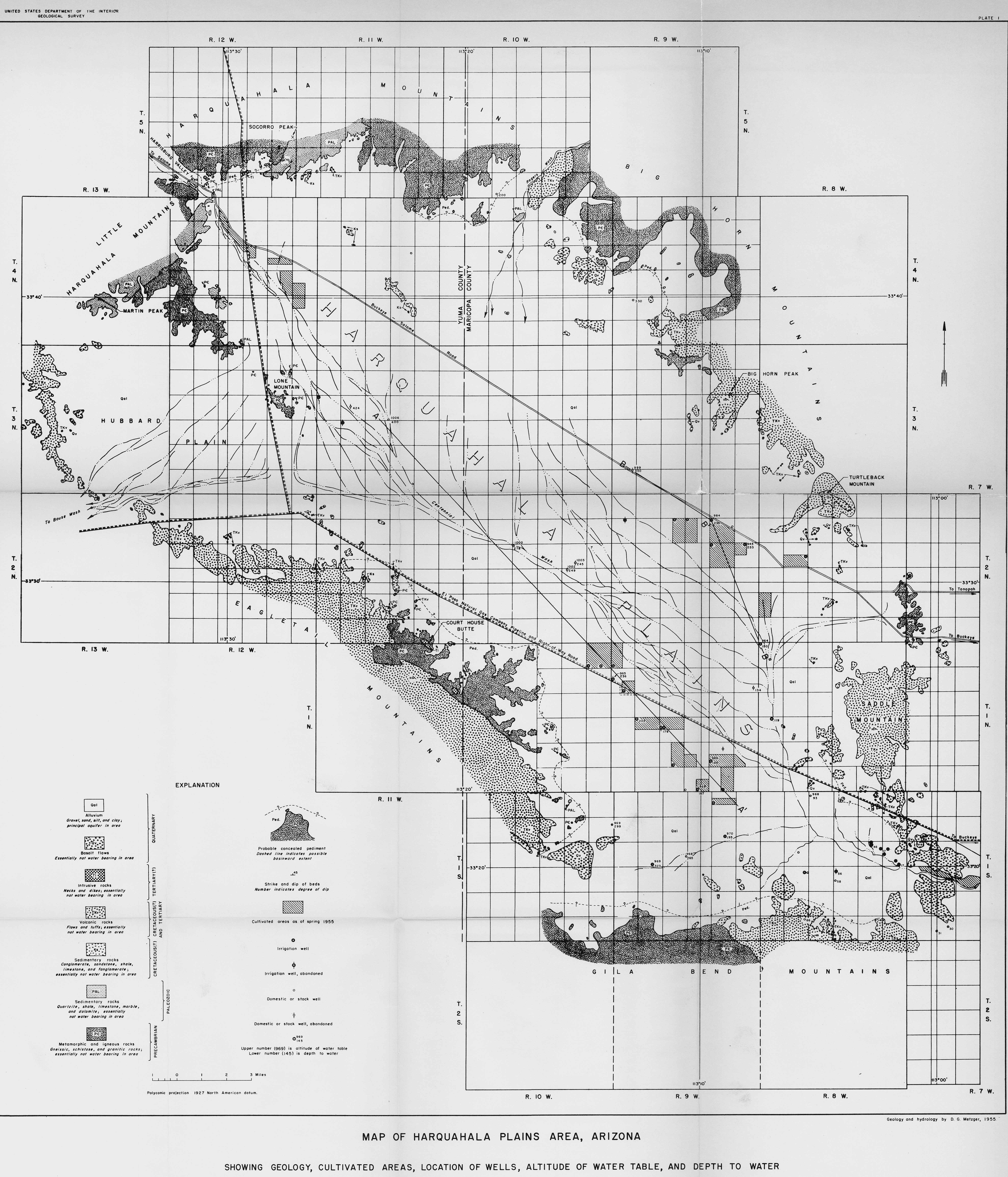
Geology and Ground - Water Resources of the Harquahala Plains Area, Maricopa and Yuma Counties, Arizona

Basic Information
Author: 
Metzger, D.G.
Description: 
Study of ground water resources of the Harquahala Plains. Hydrologic, geographic and geologic summary. Qualitative report of general relationships and relative magnitudes between hydrologic parameters.
Publication Date: 
Sunday, September 1, 1957
Resource Language: 
English
Intelectual Originator Contact
Organization Name: 
Arizona State Land Department
Street Address: 
1616 W Adams St
City: 
Phoenix
State/Province: 
Arizona
Postal Code: 
85007
Country: 
United States
Phone: 
602-542-4631
Resource Information
Resource ID: 
http://resources.usgin.org/uri_gin/dlio/72
Resource Distribution Contact
Organization Name: 
Arizona Geological Survey
Street Address: 
416 W Congress St. Suite 100
City: 
Tucson
State/Province: 
Arizona
Postal Code: 
85701
Country: 
United States
Phone: 
520-770-3500
Fax: 
520-770-3505
Geographic Extent
North bounding latitude: 
33.8457
South bounding latitude: 
33.1035
West bounding longitude: 
-113.774
East bounding longitude: 
-112.791
Previous Citation
Bibliographic Citation: 
Metzger, D.G. 1957. Geology and Ground Water Resources of the Harquahala Plains Area, Maricopa and Yuma Counties, Arizona: Arizona State Land Department, Phoenix, Water Resource Report 3, 39 pp.
Syndicate content